|
Where do I start other than to say that the 2025 Spring and Summer storm season has been the worst I've ever experienced in life, at least up to the present time of writing. Honestly, I consider myself a very patient and experienced person when it comes to dealing with the emotions and frustrations when sky events consistently don't work out and have learned to take it in my stride as something good always comes along to balance the elemental scales. However this season has tried my patience and stretched my zen mind set to the absolute limit.
Never have I ever seen such an inactive dull season when virtually nothing works out. I don't ask for much really, all it takes is one or two 'good' days to make an entire season, in fact, it was one such good day at Ballyronan Marina during the 2024 season which made the year for me in an otherwise quiet Summer so it's not as if I'm that hard to please, however I do have certain standards which need to be met such good surface based multicells, strong updraughts, flanking lines, well defined dark bases, a good funnel cloud, or just good mean looking dramatic stormscapes, that's what I'm after, I always see something good every Summer and in some occasions I get spoiled with good action such as the legendary 2023 season. This current pathetic excuse we have for a Summer is just beyond a joke.
Spring got off to a great start with an extended period of warm sunny HP which was utter perfection, all of us enjoyed that, however I was hoping either a break down or a classic SWly unsettled period would arrive for a while at least, but it never did. N. Ireland consistently ended up getting the wrong end of the synoptic deal in the N sector of the unsettled or cooler air, stable cool Atlantic nonsense which kills CAPE and sends all moist humid unstable air S away from us. Then we did get several good set-ups, one of which was significant, I can't recall the date as I have such little respect for the day that I won't even look it up. 3000j/kg of CAPE, strong shear, hot temps, convergence and cool air aloft all appeared over the W coast of Ireland, there was a big division in the models, some showed storms over Donegal and Sligo while others showed bone dry conditions. The risk of a bust was high but if it went the other way then the glory would all be ours with potential for a nice isolated severe thunderstorm in the evening, we got lured out.
My dog Rhua and I went to Mullaghmore in Co. Sligo, we met up with Nigel McFarland and Paul Martin and spent hours on location. Max temps were 29c however the van was reading 40c over a hot section of melting tarmac. With no shelter on the coast we we were exposed to hot sunshine for hours as we waited for something to happen. When I first saw convection I was immediately disappointed, it was all elevated, the worst kind in my opinion, I knew things wouldn't get good after that, but if we got a storm then at least that would be something. But no, the atmosphere tried over and over, due to a strong cap and issues with dry air aloft towers turned to mush and shredded, we had one good attempt at an updraught base which died and we knew things were bad when I got over excited by one drop of rain hitting my face, we didn't even get a shower, it was dry, game over. The long drive back is less fun when you bust with nothing to show for it. I didn't even fly my drone once as I was so deflated all day, however it was still great to see Mullaghmore again and the coastline and castle were great not to mention meeting the guys, we did our best and showed great dedication against all odds.
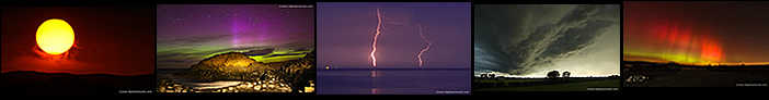
The following evening there was another chance of storms, same set-up, but with 800 CAPE and good surface based potential, storms might fire late in the evening when a cool pool moved in. I took a chance and drove to my target area on the north coast overlooking Lough Foyle, I reckoned there was a good chance of a storm there. Colleen Webb also joined me, upon arrival I knew it was another disaster, convection could be seen all over Donegal yet it was all elevated once again. It was June 21st, the Summer Solstice, so we stuck around to shoot the sunset but even that was covered in cloud. Lots of showers broke out in the W but once again they were all capped and had dry air issues, not one rumble in the entire country. At 22.30 we called it a night defeated, another bust with trash skies. Then not after I got home big c-g lightning strikes struck down over the Magillian area around midnight, I couldn't believe it, at our very look-out spot later than expected and it was the only lightning in the entire country, it was a like a slap in the face from nature. Meanwhile England and Scotland were getting severe thunderstorms all day and evening, a MCS and at least two supercells, we could actually see the tops of the Scottish storms from the coast but the summer twilight sky was too bright to see lightning, had it been a dark August night we could have been hunting for Sprites from the English storms.
This was the other frustrating thing, Ireland would show big energy for a couple of days, then at the last moment everything would shift E over England and they would get a big show with severe storms and epic night lightning displays. Worse was when Ireland and England both shared great instability with an approaching trough/front from the W, the front did nothing for us, always dry or else normal boring rain yet the same front would trigger storms for England, it seemed that Ireland was cursed, nothing was working out, we where just in the wrong position to get the full engagement of all the synoptics required to get storms. At this stage I honestly had a bad feeling that the season was not going to get better at all and I had lost all hopes for anything exciting. The following day June 22nd had some potential, this time surface based, but a Wly flow with borderline tops but with CAPE values of only 100-200, yet the shear was in the 30-40 knot range. It was more blustery with cold air mass showers and it looked messy on the charts, I didn't hold out for much.
 |
That day Roisin, Rhua and I went to the coast for a day out, I had studied the models first and although I considered inland to be the best place for a storm, especially in the E, I did notice some models showing a few cells along the coast, so maybe we would see something while we where there. We walked along Magilligan beach when I noticed convection over Donegal slowly moving in our direction, I said to Roisin those showers look to have a weak gust front forming and that we could end up getting soaked in a while, we were standing under lovely warm sunshine and Roisin suggested we turned back as she didn't want to get rained on so we returned to the car. Then the cell moved closer, the sky began to cloud cover and the leading edge of the cell turned mean with a long staggered line of beefy dark clouds marking the leading edge, it began to get my attention so I made my way back down to the beach again and got the drone in the air.
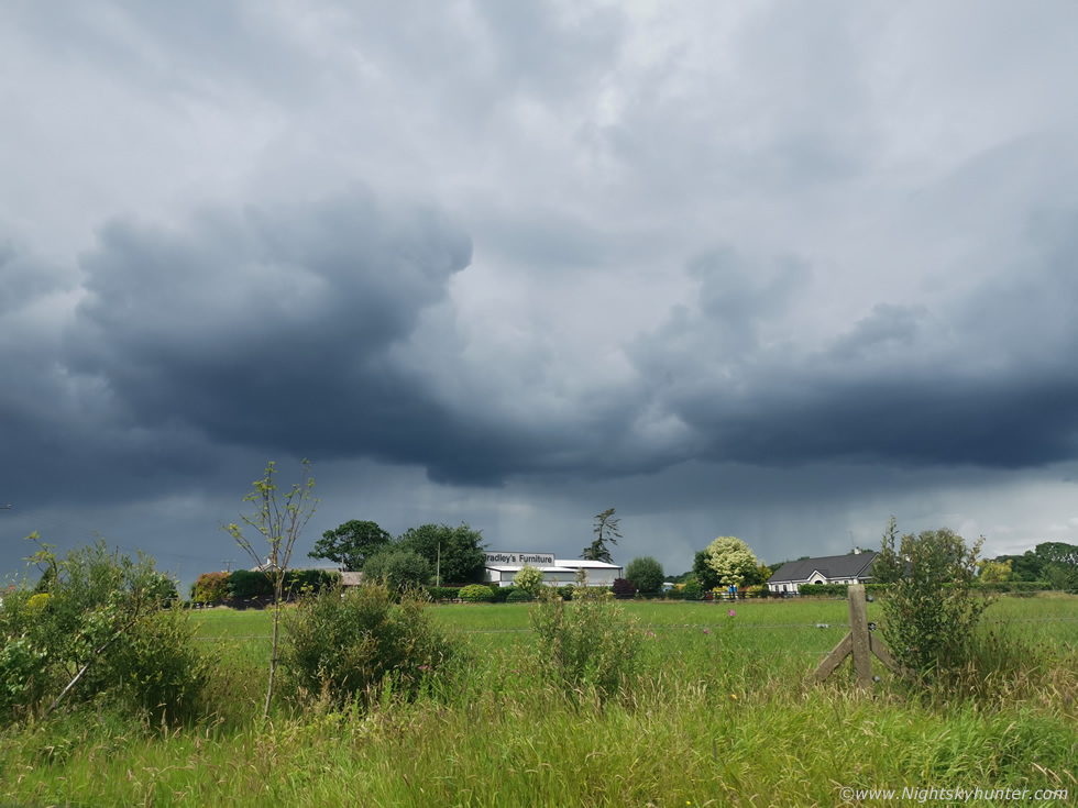
Sunshine shone through breaks in the hazy cloud illuminating the golden beach, the green water, and orange sand banks below which contrasted beautifully with the dark storm clouds above. Then the rain hit clearly catching everyone off guard, walkers on the beach, people paddling in the water, they all got hammered by intense wind driven rainfall which was red on radar, the outflow was strong and squally. It amazed me how not one single person looked at the sky and seen this coming, I had it spotted 20 min's in advance just from reading the sky, maybe others just don't look up enough, but for me it's a full time occupation and old habits die hard. In any event this turned out to be the best convective scene I've got all Summer, actually all year, on a day when the models were not showing big CAPE values, no warm sectors, when expectations were low, and you know why it produced a cool scene?, it was because it was surface based, this underscores once again that SB convection/showers/storms have a much greater chance of being dramatic for photography than their elevated counter part. I wouldn't give elevated cells the time of day...unless they happened at night but that's a different and more rare story. As it was I was happy with this nice storm scene even though it was non-electrified, but thunderstorms did break out in the E soon after so the day worked out fine for such a marginal set-up.
 |
There were other minor chases which all ended in disappointment, same story of capped, dry air, high based, ugly, too cloudy or skies which looked like a scene straight from Autumn. The next main event was a cold front engaging warm moist air with SB CAPE and -40c tops with enough shear for supercells. Tony Gilbert issued a rare outlook for long track tornadoes, I don't think I've personally ever seen a forecast like that for Ireland. There was some degree of confidence of some good lightning and the models hinted at a widespread long duration shelf cloud being possible, that was my goal. I spent all day out, actually chased three times, staying ahead of the cold front, no lightning at all, however I did see strong rotation near Moneymore associated with no rain, it was the strong low level shear at work. Roisin and I chased ahead of it and and got no shelf, just a grey line like a normal wet day seen in Autumn, that was yet another let down, but a friend of mine did get a decent shelf cloud from Dungannon ten miles down the road from me, it must have weakened when it arrived with us, so that was another chase day which yielded no results.
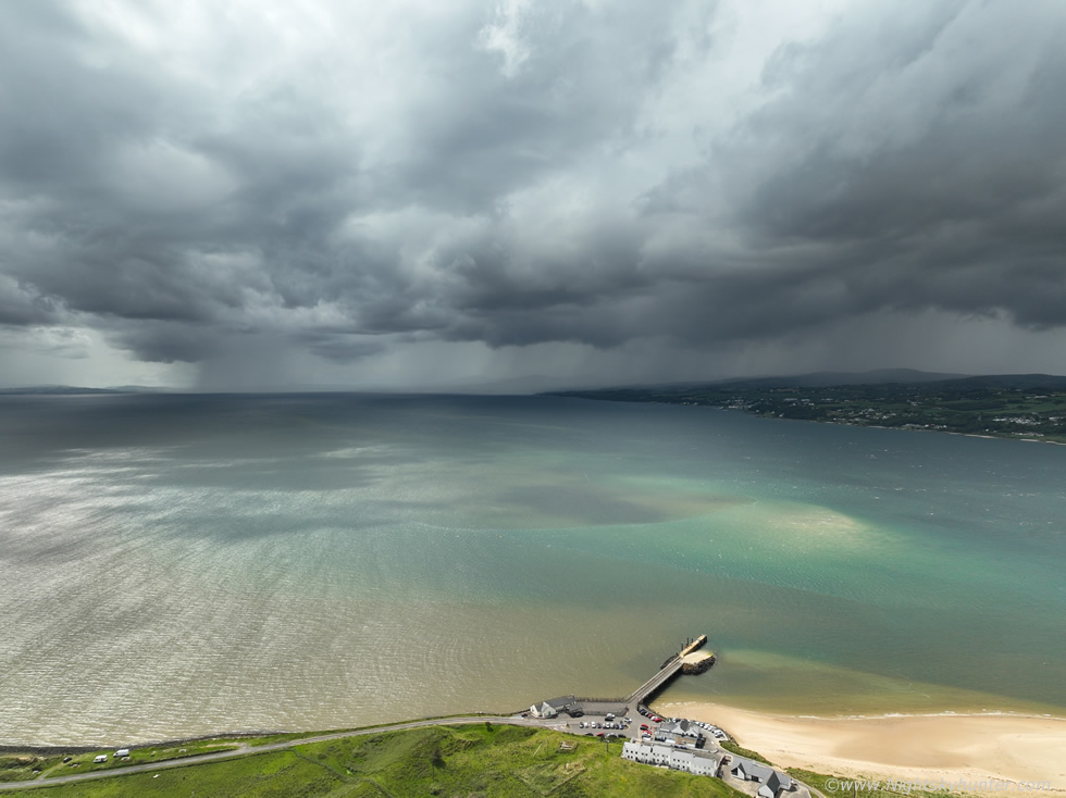
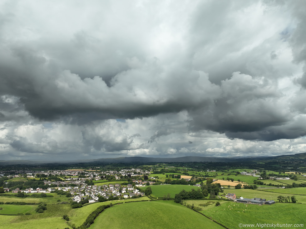
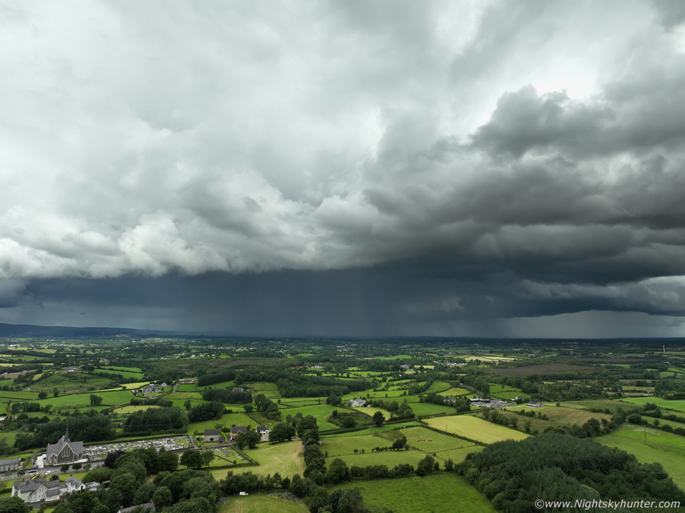
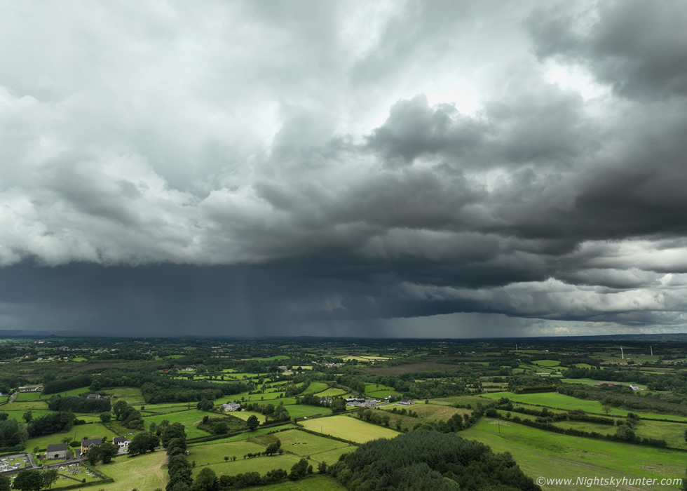
There was a day which showed some hope which got my attention on July 2nd when a trough would cross the country during the mid afternoon with surface convergence, -20c to -30c tops, low level shear and enough deep layer shear during the mid afternoon period to produce brief multicellular activity, in fact, by 15.00 the 0-6km shear was between 30 and 40 knots with up to 400-500j/kg of CAPE, this would be a classic NI Wly flow cold core set-up which meant good visibility and surface based activity, I suspected this day might just yield something of interest. The E part of the country offered the best prospects so my target area was the Ballymena/Slemish region of Co. Antrim. Roisin was off this day so we went chasing together with Rhua for a day out, in fact, Roisin hadn't been on a proper chase for a long time with me so this would be the first all day chase in a while, we brought a flask, supplies, home made sandwiches, we had planned on leaving at 11am sharp from Cookstown. When I took a look outside I knew instantly it was going to be one of those better days with increased photo potential. The air was clean with good visibility, there was random convection all over the place and early showers already breaking out, white anvils and dark bases with blue skies all around them, this was more my kind of day. Suddenly there where lightning sferics recorded between Cookstown and Omagh so I got the drone up to look W (above image). Nice beefy cumulus clouds slowly approached over the lush sunlit countryside, if you look carefully in the distance in the middle you can see a white anvil, that was the storm, it was moving E so we got on the road to check it out.
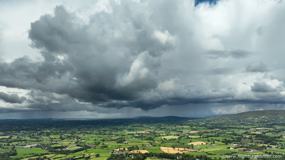 |
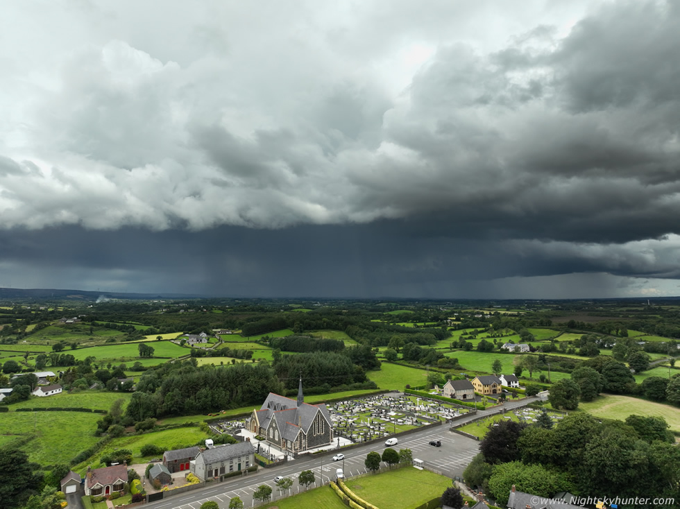
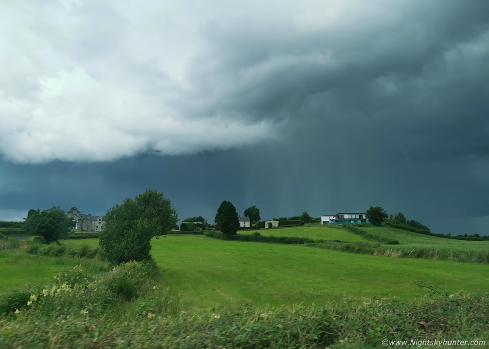
Drone up outside Moneymore looking W with part of Slieve Gallion on the right. That was the remains of the storm, it had stopped producing thunder and I had never heard any previous to this but knowing it had been a recent storm added to the excitement. As it approached it began to produce precip again and eventually started to form a weak gust front over the town with strengthening precip curtains, it looked like another storm brewing but it struggled to rumble. The clock was ticking and we were a little behind on getting to our target area so we wasted no more time with it and drove E.
 |
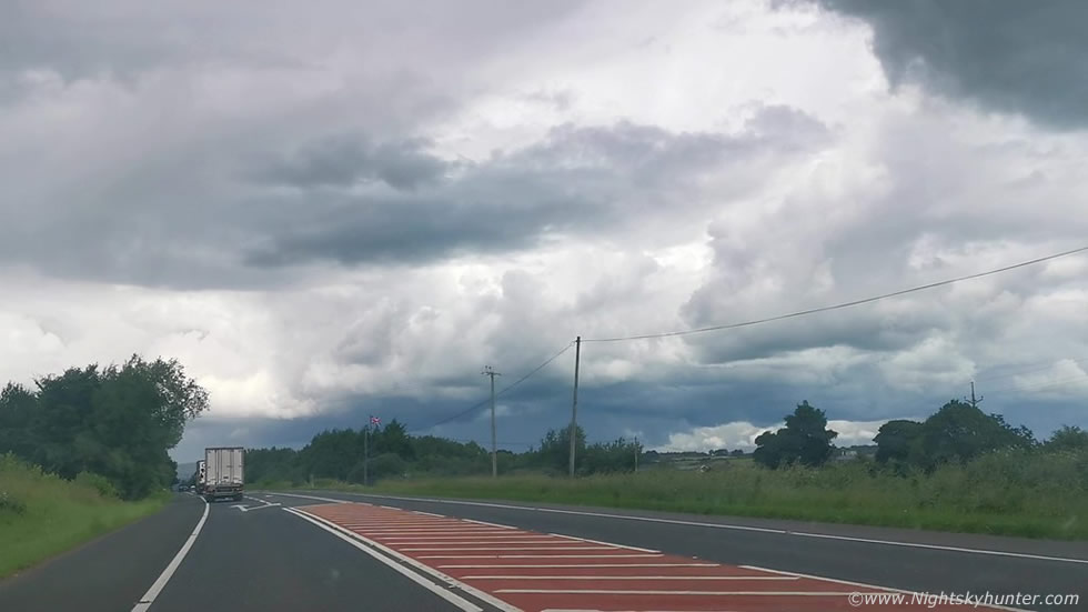
Roisin was driving for the first part of this journey which meant I could shoot images and footage using my phone from the passenger side which was a rare luxury. This was still the Moneymore cell, which was now chasing us, we where just about able to stay ahead of it, not far from Castledawson roundabout here.
 |
Then while advancing towards the Maghera end of the Glenshane Road we spotted a new cell dead ahead and this one actually looked good and had a lot going for it visually. It was young, rapidly developing, already had a dark precip core and the white convection with it was beefy and solid, furthermore it was moving E to our target area where it would move into an atmosphere with strong CAPE, we gave chase. We took the turn off for Knockloughrim, passed through Mayogall then pulled into a layby near Gulladuff.
 |
Looking W/NW, the cell had crept over the Glenshane/Maghera area and was moving E towards Ballymena. I was flying the drone from Gulladuff, I knew this could be my best chance of capturing it's structure before the precip filled out. It was a big solid high contrast cell in quite harsh light, to the eye the sides and top were brilliant white in the sunshine which was quite uncomfortable to gaze at, while below the core was very dark with hints of that classic thundery blue tone, the precip core was constantly red on radar, this was a developing thunderstorm.
 |
Storm cell with Gulladuff Chapel, I didn't see an anvil above the cell just glimpses of big solid white billowing towers. I took a few stills and shot some footage fully aware the clock was ticking again, I couldn't hang around too long or we wouldn't be able to catch up with it again, but I can tell you something, I was actually happy for the first time this season to be capturing a developing thunderstorm, it had been a long time.
 |
Parting image of the E moving storm. I got back in the car and asked Roisin to hit it and we surged E through the bending tight turns of the dangerous country roads between there and Portglenone.
 |
More passenger seat filming, the cell was now producing curtains of hailstones and was intensifying fast, moving L to R and note the subtle dark lowering under the updraught base behind the precip core, I knew that core was good and based on our trajectory we would be intercepting it in no time. We quickly pulled over and switched seats and now I was driving, we entered Ballymena town, got half way through when the core hit. It was absolute monsoon levels, the roads were filled with running water, the gullies and manholes were overflowing and the roads were starting to flood, the wipers were on full speed and we struggled to sea out the windscreen a times. We were astonished and delighted to see the grass verges near junctions and mini roundabouts covered in laying hail stones, Summer had turned to Winter in an instant. Then a pink flash of overhead lightning, at first I thought I had imagined it then another came, both intra-cloud bolts, Roisin saw them too, we yelled 'lightning!!!' with great joy, we where directly under an intense thunderstorm. I said to Roisin this was the exact area I had expected a storm to happen and here we where in that exact area under a storm, I don't know if it was good model guidance or good instincts or a bit of both but it was a very good feeling.
We didn't actually hear any thunder however the rain was hammering that loud with surface water splashing under the wheel arches it likely drowned out the sound. It was then I got a text message from Paul Martin saying he was hearing thunder from the Ballymena area and hoped I was on it, he was working near Toome and heard the rumbles from there. We cleared the town into the countryside and another pink overhead bolt whip lashed through the rain, I put the window down and this time we heard the thunder. This was the first close range lightning/thunder we had experienced all year and it was hard earned I can tell you. I felt an instant sense of relief, at last a storm, it almost felt surreal. On radar the storm had a large persistent white core and showed numerous sferics which indicated it had more lightning than we had seen, it would turn out to be the best cell in the country and only storm in N. Ireland so talk about great timing. Of course we got no footage of any of this action, my dash cam has stopped working and my window mounted Go Pro only turns on when it wants to so this entire flash flooding and rain encounter was a visual experience.
We drove to Slemish, the storm was spent and slowing cleared and we were back to blue skies and warm sunshine. Convection developed but I could tell it was nothing like before, the trough had passed through and I suspected the best instability had moved through with the storm. Still we waited for several hours enjoying the beautiful view, going for walks and watching every convective cloud in sight until 16.00 when we decided to move on. We both really enjoyed the scenery and the storm, it was a good day out. I wonder will this be my only storm encounter of the Summer?, I hope not, even though I enjoyed the experience I still hadn't got the structure scenes I wanted so the thirst for more storms continues, maybe nature will throw us a wonderful surprise before the season ends. Thanks very much for reading my personal rant, especially if you have made it this far.
Martin McKenna